Distance: 7.94 miles
Time: 3 hours 30 minutes
On today's walk, we cover five trails in the north-east and midsection of Galbraith Mountain. We do this with a through-hike of Galbraith, starting in the south end at Padden Trailhead parking lot on Samish Way, and ending up on the northern edge of the mountain at the Birch Street parking lot.
It's a long hike, and given the warm forecast we decide to make it an early start. We drop the van off at Birch Street and my wife shuttles me and Raney to the Padden trailhead. We start walking at about 8:00am; these summer days, the sun is already high in the sky at that time.
 |
| View of Mt Baker from Road 4000. |
 |
| Today's through-hike traverses Galbraith Mountain from south to north. |
From the Padden trailhead, we cross Samish Way and make our way up
Galbraith Lane, to the Checkpoint Alpha kiosk. (0.6 miles, 11 minutes
from the parking lot.) The plan is to gain our altitude on the south side logging roads, and then descend on the north side of Galbraith on a series of trails.
We follow Road 2000 northward, coming to the Road 3000 intersection marked by the "blue rock." (1.4 miles, 28 minutes.) We take the right fork to follow Road 3000.
About ten minutes later we reach the meeting of Roads 3000 and 4000. (2 miles, 40 minutes.) We follow Road 4000 on the left, which veers northwards. (Road 3000 heads toward the Galbraith Summit on the south side.)
Raney starts her little side excursions in the woods, smelling along the animal trails. I decide it's a good time to attach the bear bell to her collar. At 2.2 miles, 44 minutes, we pass by Mullet trail on the left side.
 |
| Topping out on Road 3000. |
 |
| Bikers planning their route, at the junction of Roads 3000 and 4000. |
We reach Road 4100, which rises steeply to the right. (2.3 miles, 47 minutes.)
Staying on 4000, we continue northward. The trail is topping out here - not much mountain left above us, just blue skies.
The incline gets more gradual here. This is my first time on Road 4000 and I'm enjoying the views of Mount Baker to the east. Raney's more interested in the rabbit that crossed the road just a few feet in front of her.
Before long, Road 4000 begins to descend. It continues to lay out vistas of the mountains to the east, and occasional glimpses of Bellingham to the west.
At 2.5 miles, 53 minutes, we suddenly come upon a clearing. This is the four-way junction with Road 4010 on
left and Road 4000 off to the right. We're going straight through, which puts us onto Road 4200 towards Supercross trail.
 |
| Road 4100 splits off steeply to the right from Road 4000. |
 |
| Daisies cover the side roads along Road 4000. |
 |
| The view looking eastward... |
 |
| ...and westward from Road 4000. |
 |
| Junction of Roads 4010, 4200, and 4000. |
Heading up Road 4200 from the junction, we note the start of Keystone trail on the left. We'll be hitting that trail on the return trip, after we hike the Supercross and Devilcross trails.
On the downhill slope now, we get beautiful wraparound views of Mount Baker, and Galbraith peak with its telecom towers.
At 2.7 miles, 1 hour, we go through a bit of a logged area, and we go by Road 4210 which veers off to the right. We're close now to the start of Supercross trail.
 |
| Hard to see in this pic, but Mount Baker and the twin sisters are visible along this part of Road 4200. |
 |
| In the distance, Galbraith peak with its telecom towers. |
We duck under some recent windfalls, and at 2.8 miles, 1 hour 4 minutes, we go by a path that *might* be Supercross. Unsure, we go a bit further on Road 4200 before deciding it's the one and turning around.
Supercross is a delightful trail. It's in a parklike setting, and the narrow trail has a natural floor of moss, crushed leaves, and pine needles. Those must feel good to Raney's paws after several miles of walking on gravel logging roads. Above, large bows of fir trees make a shady canopy.
The trail descends steadily, until it ends on Road 2700. (3.25 miles, 1 hour 17 minutes.) Turning left on Road 2700, we find the entrance to Devilcross on the left. (3.4 miles, 1 hour 20 minutes.)
We begin the steep ascent southward. Devilcross has a different personality from Supercross. Both trails run roughly parallel, but Devilcross has much steeper sections, with tight corners and the track going over moss-covered boulders. It's definitely a black diamond mountain bike run.
If I do the hike again, I'd recommend going down Devilcross and back up Supercross, which gives an easier climb given the different terrain between the two trails.
At 3.6 miles, 1 hour 28 minutes, Devilcross opens up in a field of daisies, leading back to Road 4220 and Road 4200.
 |
| Recent large windfalls cross the road towards Supercross. |
 |
| Entrypoint to Supercross trail. |
 |
| This zoomed-in view shows the Supercross / Devilcross loop that we walked today. |
 |
| Raney on Supercross trail. |
 |
| End of Supercross trail. |
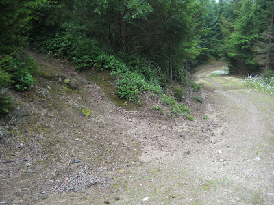 |
| Lower access to Devilcross trail. |
At this point, we retraced our steps to come back to Keystone trail. (4.2 miles, 1 hour 48 minutes.) Keystone is another narrow trail, wedged in between small Christmas-sized fir trees. The trail descends as we work our way westward.
After about ten minutes, Keystone crosses a logging road, which is not on my map.
Keystone continues through a logged area, where we're treated to nice views of Bellingham and the Canadian mountains behind it.
The trail crosses a small clear stream at 4.5 miles, 1 hour 55 minutes. Raney dips her feet and takes a drink. Just past the creek, we climb up a hill and see Bottle Opener trail entering from the left.
Keystone trail ends at the junction of Roads 2720 and 2722 (marked with Road 264 signage). Shortly we come upon an unnamed trail that leads from here to Oly trail. I christen this trail "Oly East." Oly East is an easy trail to miss, but there's a helpful cairn on the left side of the road. We head north on Oly East. (4.7 miles, 2 hours 5 minutes.)
Oly East is descending in this direction. It's somewhat overgrown, with some stinging nettle to avoid, but it's still a good shady trail.
At 4.9 miles, 2 hours 10 minutes, Oly East meets Oly. We turn right on Oly, which is fairly flat in this stretch - we're near the top of this part of the mountain.
We reach the end of Oly in ten minutes, when it turns into an overgrown logging track, Road 2050. We can see Lost Soul trail leading off to the right, but we save that for another day. We turn left on Road 2050, and in a few steps we're on Road 2000 (Arsenio Loop), where we go left.
Road 2000 is a familiar route that takes us past the entrances to 2 1/2 Trail and Cabin, and leads us to Road 2500. (5.5 miles, 2 hours 28 minutes.) Our aim from here is to find Cleavage trail, so we turn right on Road 2500, then left at the fork to Road 2510.
Road 2510 leads to the start of Cleavage trail. (5.7 miles, 2 hours 32 minutes.) The trail descends in this direction. It's a nice cool path, fairly wide, and well maintained.
 |
| A small cairn marks the entrance to "Oly East." |
At 6 miles, 2 hours 40 minutes, we reach a point where Cleavage meets Intestine. It
looks like Intestine is the preferred route by mountain bikers. Wanting to complete the walk on Cleavage, I go straight on Cleavage which degenerates into a rutted out road.
Various trails interconnect here, and somehow we end up on Road 1200. We follow Road 1240 to the right, and head on a road labeled 106. This road peters out and becomes a trail that we recognize as SST. We follow SST, heading downhill and north.
 |
| In an anatomical improbability, Cleavage meets Intestine. |
From here we head out on our familiar SST route. At 6.7 miles, 3 hours 3 minutes, we go by Checkpoint Lima. We reach Powerline trail at 7.1 miles, 3 hours 10 minutes.
Turning left on Powerline, we take it to Back Door, and follow Back Door out to Birch Street. Tired but satisfied with our through hike today, we reach the van at Birch Street parking lot. At 7.92 miles, and 3 hours 30 minutes, it's our longest hike on Galbraith to date!


