Time: 3 hours 5 minutes
Today's hike is another long one, and it's the perfect day for this scenic route.
 |
| Water break for Raney, with views of Lake Padden and Bellingham Bay. |

We cross Samish Way from the Padden Trails parking lot, and head up to the kiosk marked Checkpoint Alpha (0.5 miles, 11 minutes from the parking lot).

Partway up Road 2000, we meet a runner with a dog. She recognizes my Sehome cross-country shirt, and we chat for a bit as we both have daughters in XC. She lost her dog here yesterday, a friendly brown pit bull. A mountain biker was descending speedily down the road yesterday, and the dog suddenly bolted across the road. They collided, hard. Spooked, the poor dog took off into the woods and she hasn't seen it since. I get her name and promise to keep an eye open for the dog.
Note: the Galbraith maps indicate colored rocks as landmarks at major junctions. These are small and most are worn away; the photo below shows the Blue Rock that marks the meeting of Roads 2000 and 3000. We're turning right to follow Road 3000 (1.4 miles, 31 minutes).

Below is the worn Red Rock marking the meeting of roads 3000 and 4000 (2 miles, 42 minutes). We stay to the right on 3000. We've had some shade from the sun up until this point, but now we're in the open sun and it is getting warm quickly - even at 8:30 in the morning. We're going to go through some water today; I'm glad I brought a litre of it for me and Raney to share.

 |
 |
| Entrance to Pump Track trail. |
We hit Checkpoint Delta at 2.4 miles, 51 minutes. From here, Scorpion trail comes in on the left. It's a direction trail, meaning it's a one-way downhill-only trail.
On the right is the striking entrance to Unemployment Line, with its wooden bridge stunt.
We'll hit both of those trails on a future hike; for today we continue upward on Road 3000. Shortly after checkpoint Delta we go by Road 3200 which extends southward; we branch left, staying on Road 3000, towards the summit.
 |
| Entrance to Unemployment Line trail. |
 |
| Scorpion is a one-way trail. Downhill only! |


At 2.6 miles, 58 minutes, we go by what is technically Road 3010. It's very overgrown. If we took it, we'd intersect with Whoopsie Woodle, but instead we're going to go closer to the summit so that we cover the entire trail.
 |
| Junction of Roads 3010 and 3000. |

Just past Road 3010, we go by a large telecom station with satellite dishes on top. Beyond that, Road 3000 branches to the right (2.8 miles, 1 hour 4 minutes). We could take that to the beginning of Whoopsie Woodle - but instead we take the left road (marked 303) to take the short remaining walk up to the summit. The plan is to then descend Silver Rock trail to get back here.


At an even 3 miles, 1 hour 10 minutes, we reach the Galbraith summit. A marker here is labeled Checkpoint Echo.
I've been hiking on Galbraith, mostly on the north side, for ten or twelve years; today is the first day I've walked to the summit of the mountain.


 |
| Zoom-in of GPS route shows the tower area, Silver Rock trail, and the beginning of Whoopsie Woodle. |
We walk past the first two towers, and past Scorpion trail on the left, to get to Silver Rock trail. The trail entrance is on the right, between the 2nd and 3rd tower on the summit.
Silver Rock trail drops sharply. It is essentially a little ledge on the side of the mountain. It's fun to hike but I'm glad I'm not biking here - it's quite a drop-off on the left side. It's a short trail and at 3.1 miles, 1 hour 15 minutes, it pops us back out onto the road. Now we take the road to the left to find Whoopsie Woodle.


 |
| Whoopsie Woodle trail entrance. |
After a short straightaway we enter Whoopsie Woodle (3.2 miles, 1 hour 19 minutes). As we turn off, the views begin with scenes of mountains to the west and southwest of us. I can tell already that Whoopsie Woodle will be one of our favorite trails. It either hasn't been logged, or was harvested long ago, and the soaring views are great.


At 3.6 miles, 1 hour 33 minutes, the trail comes up to a T. Turning right would put us back on Tower Road; we're turning left to continue on the trail.
As Whoopsie Woodle meanders southward, we start to get nice views to the southwest of Lake Samish, and layers of mountains and valleys all around.
The warm day is bringing out the smell of the fir needles, and adds a pleasing fragrance to the viewing experience. Looking behind us on the trail, we can see the rounded dome of Mount Baker peeking through the haze.


It's buggy today, so our stops are short. As long as we're moving there's enough of a breeze to keep them at bay. Far down below I can see I-5, and the road leading across the interstate to Lake Samish.

 |
| A raven flies overhead. No owls today... |


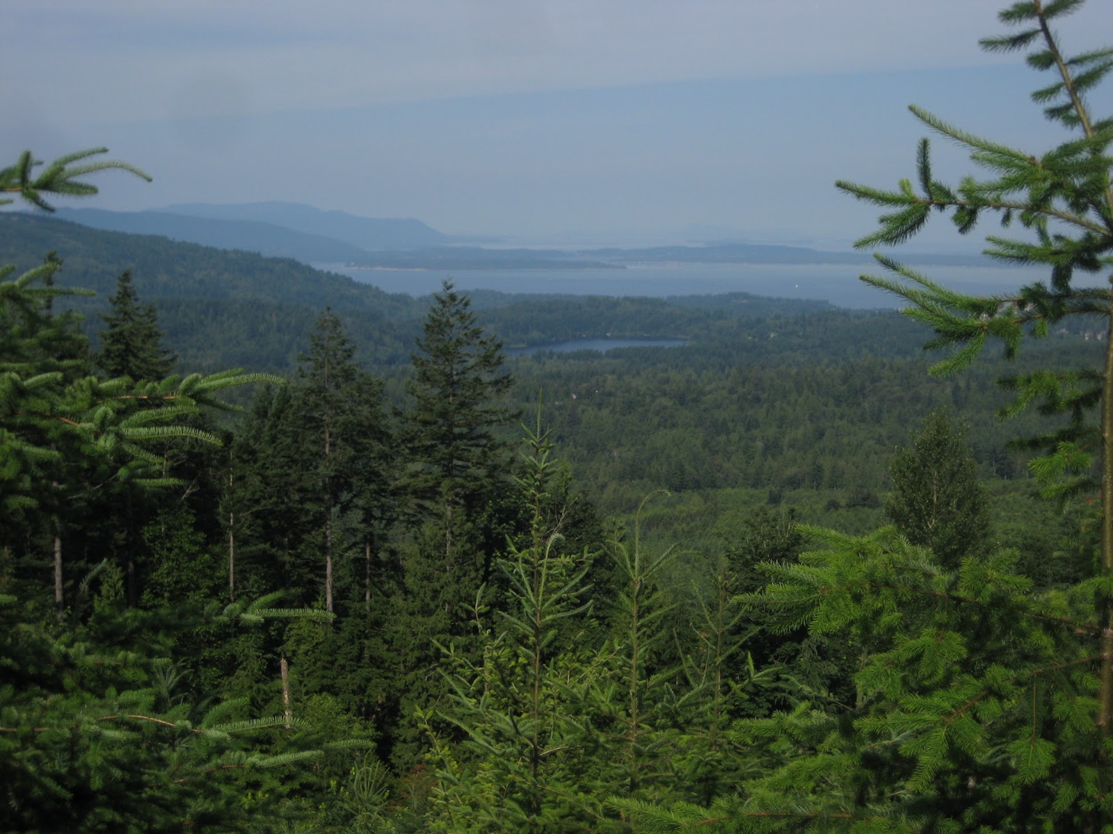
From here the trail curves northward, and offers new views: of Lake Padden and, behind it, the boats on Bellingham Bay.
Lake Padden looks a long ways off from here; it's marvelous that there are trails all the way from here down to the lake. What a treat that we have this trail system on Galbraith Mountain.


Eventually the trail re-enters the thick canopy of trees. After the bright sunlight, it takes a while to adjust to the darkness. The coolness of the canopy's shade is a nice relief from today's heat.
 |
| Raney sporting her red "bear bell." We jingle all the way through Galbraith. |


At 4.9 miles, 2 hours 19 minutes, we eye a little trail heading off to the right. That must be the orphaned trail known as Prison Love or Gerry's trail. It looks like it has been used recently, but it is orphaned according to my map.
We continue straight on the left fork which keeps us on Whoopsie. We should get to Road 2300 before too long.
The trail comes to an end at Road 2300 (5.2 miles, 2 hours 25 minutes). The road is unmarked. We look for Road 2310; we follow one likely road which is crossed by another logging road where we go left, assuming this is 2310. My compass app tells me we're heading west, so we proceed.
Our route choice seems to be confirmed when we get to an abrupt left turn on the road, at 5.5 miles. That coincides with the mapped route. It's getting buggy here - the flies are annoying and a few them are biting. It's incentive to keep moving.
In this area I see a doe off in the distance. Raney's nostrils are working overtime but she can't see it from her vantage point.
 |
| A well-camouflaged doe in the thicket. |
 |
| Raney works the side trails. |
From here we somehow get off track - the road peters out at around 5.7 miles, and disintegrates into an overgrown logging road. I don't see bike tracks, although we are heading southwest which seems correct.
We definitely missed a turn because we're bushwhacking now.
At 6.1 miles, 2 hours 56 minutes, we end up at a residential area off of Samish Way. We follow the lane out to Samish and turn right to get back to the parking lot.
Not sure where we went wrong, but I'll have a chance to try this lower route again soon, when we return to the summit to bag Scorpion and Unemployment Line trails. (Note: see this post for the description of how to get back to Galbraith Lane without bushwhacking!)


We reach the parking lot at 6.6 miles and a bit over 3 hours. I'm excited to have discovered Whoopsie Woodle and will include that in my list of favorite trails. Judging from the look of a tired but happy dog, Raney seems to agree.

Wow!! Very nice blog. Great appreciated
ReplyDeleteTrekking in Nepal
domestic flight in Nepal
mountain flight in Nepal
kathmandu to lukla flight